
UNDERGROUND UTILITY SURVEYS
PAS 128 Utility Mapping | Nationwide Coverage
CALL US: 01279 927 033


✅ Constructionline Gold ✅ SSIP Accredited ✅ Achilles Registered ✅ Trimble & Leica Equipment
✅ All Engineers PAYE — No Agency Workers ✅ £5m Public Liability & £5m Professional Indemnity
PAS 128 Underground Utility Surveys | UK Wide
Accurate Underground Utility Surveys for Safer Excavation
Before you break ground, know exactly what lies beneath.
AKN Engineering provides PAS 128-compliant Underground Utility Surveys using Ground Penetrating Radar (GPR) and Electromagnetic Location (EML) to identify buried pipes, cables, ducts, and drainage networks with precision.
We help contractors, developers, and local authorities reduce excavation risk, prevent costly service strikes, and comply with CDM Regulations 2015 (HSE.gov.uk).
Our utility mapping surveys are trusted across Hertfordshire, Essex, Cambridgeshire, Suffolk, and surrounding counties, supporting highways, civils, and construction projects of all scales.
Want to discuss a project? Call us on 01279 927033
WHAT IS A UTILITY SURVEY?
A utility survey identifies and maps underground services, including:
Gas pipes
Water mains
Electricity cables
Telecoms
Drainage systems
Fibre optics
Using non-invasive technology such as GPR scanning and cable locators, we provide detailed utility detection drawings that support planning, design, and safe excavation.
OUR UNDERGROUND UTILITIES SURVEY METHODS
We tailor each survey to your site conditions, soil type, and project requirements using the most appropriate technology:
✅ Ground Penetrating Radar (GPR)
Detects non-metallic services such as plastic water pipes and concrete ducts
Provides depth estimates and subsurface imagery
Ideal for complex or congested utility areas
Recommended for PAS 128 Type B surveys and brownfield sites
Learn more about our GPR Surveys and how radar imaging complements electromagnetic detection for full underground clarity.
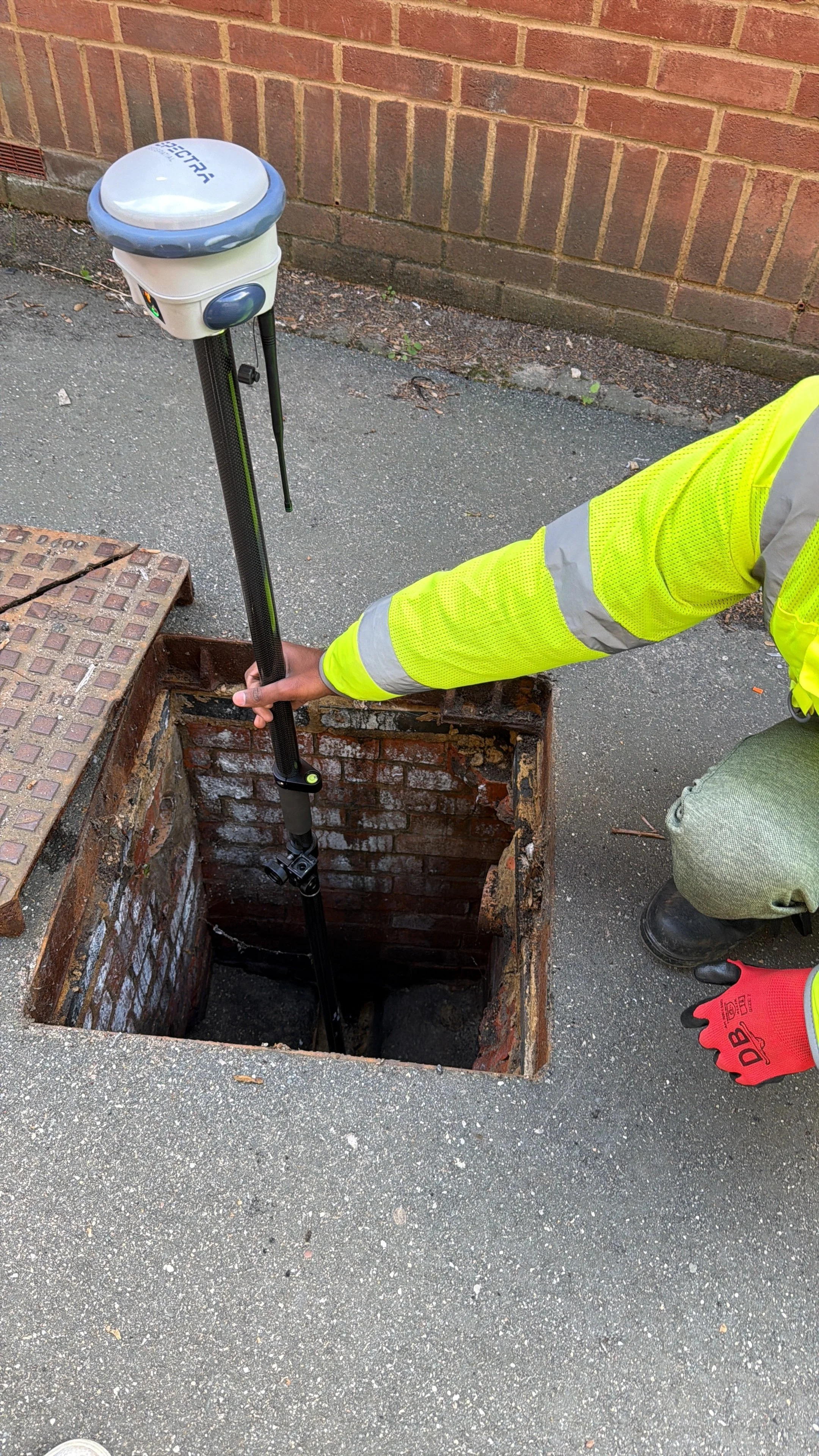
✅ Electromagnetic Location (EML)
Traces metallic and conductive utilities such as live power cables and metallic water mains
Uses industry-standard CAT & Genny equipment
Provides accurate horizontal positioning and route tracing
Ideal for PAS 128 Type B1–B4 investigations
✅ Manhole & Valve Inspections
Lifting accessible covers to record invert levels and connections
Supporting accurate drainage network mapping and verification
✅ Utility Records Integration
We can overlay statutory record plans directly into your deliverables, providing a complete picture of known and detected services in one map.
All surveys are carried out in accordance with PAS 128:2022 specifications, ensuring data transparency and measurable survey confidence (QL-B1 to QL-B4).
WHY UNDERTAKE A PAS 128 UTILITY SURVEY?
A PAS 128 Utility Mapping Survey helps you:
Comply with CDM 2015 and HSG47 (HSE.gov.uk)
Avoid costly service strikes (average repair cost £30,000–£50,000)
Improve design accuracy and feasibility during early planning
Reduce project delays and rework caused by unforeseen utilities
Support planning applications and ground investigation risk assessments
Our deliverables integrate seamlessly with your Topographical Survey or Engineering Layouts, ensuring everything aligns in CAD or GIS formats.
Want to discuss a project? Call us on 01279 927033
WHAT YOU RECEIVE
✅ Detailed CAD drawings (DWG, DXF, PDF, Shapefile)
✅ Colour-coded service types by utility (gas, water, power, telecom, drainage, etc.)
✅ Depth data and confidence levels for each utility
✅ Annotated manhole and valve records
✅ Digital record integration from statutory searches
✅ Comprehensive utility report summarising methods, findings, and recommendations
All deliverables are formatted to your specification and coordinate system (OSGB36 National Grid, local grid, or project datum).
Find out more about how we work… Call us on 01279 927033
WHEN TO REQUEST A UTILITY SURVEY
You should commission an Underground Utility Survey:
✅ Before any excavation, piling, or borehole works
✅ Prior to drainage design or service diversion
✅ During pre-construction design and feasibility studies
✅ As part of risk management or permit-to-dig procedures
✅ When verifying desktop search results before on-site works
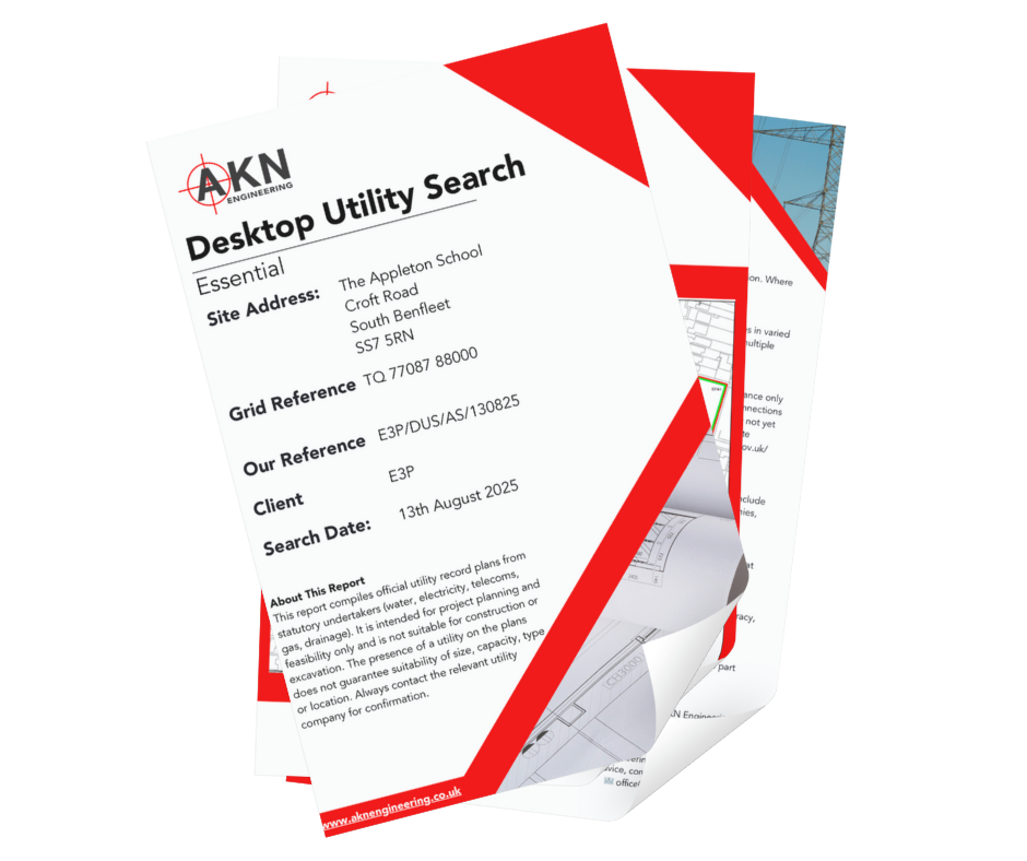
For early-stage design or pre-planning, start with our Utilities Desktop Search.
For full field verification, combine GPR and EML methods with our Utility Mapping Surveys.
TRUSTED BY


LOCATIONS WE COVER
HERTFORDSHIRE
BEDFORDSHIRE
CAMBRIDGESHIRE
NORTHAMPTONSHIRE
LONDON
ESSEX
KENT
OXFORDSHIRE
BERKSHIRE
NORFOLK
SUFFOLK
LINCOLNSHIRE
RUTLAND
AKN Engineering is based in Bishop's Stortford, CM23, and covers the above regions as standard. Projects outside these areas considered — please call to discuss.
FAQs
-
We can detect most metallic and some non-metallic utilities, including electricity, water, gas, telecoms, and drainage. GPR can also help locate buried ducts and voids, identifying where they run rather than inspecting their condition.
-
EML detects conductive utilities by tracing signals through metallic cables or pipes. GPR uses radar waves to identify buried features—including non-metallic services and obstructions.
-
Yes—especially in urban or brownfield sites. A utility survey helps avoid accidental strikes, protects personnel, and ensures legal compliance with CDM Regulations.
-
Yes. We can carry out surveys to PAS 128 specification, providing clarity on detection methods, quality levels, and survey confidence.
-
We can usually attend within a few working days following a PAS 128 Type D Survey (Desktop Utility Records Survey).
-
Absolutely. We offer combined surveys to save you time and cost—giving you surface and subsurface data in a single, integrated package.
WHY CHOOSE AKN ENGINEERING FOR YOUR UTILITY SURVEY?
✔️ PAS 128:2022-compliant survey standards
✔️ Experienced GPR and EML operators
✔️ Accurate, layered CAD deliverables
✔️ Rapid response times and flexible scheduling
✔️ Integrated data from desktop to site detection
✔️ Transparent reporting with confidence-level notation
Our team combines engineering insight with practical on-site experience, ensuring your utility survey data is not just compliant — but actionable.
Request a Quote
Ready to request a quote for your Underground Utilities Survey?
Fill out the form below, and we'll get back to you the same working day.
Book Your Utilities Survey Today
Need clarity below the surface? Get in touch with our team for a free quote or to discuss the best survey method for your site. Click the button below and share your information and we’ll get back to you the same day
Prefer to speak? Call us on
01279 927033
OUR SERVICES
SETTING OUT SURVEYS
MEASURED BUILDING SURVEYS
AS-BUILT SURVEYS
TOPOGRAPHICAL SURVEYS
SITE ENGINEERING
PILING SETTING OUT
DESKTOP UTILITY SEARCH
VOLUME ANALYSIS
UNDERGROUND UTILITY SURVEYS
3D LASER SCANNING SURVEY
GPR SURVEYS
DRONE SURVEYS
TRUSTED BY

RELIABLE UTILITY DETECTION AND MAPPING
AKN Engineering delivers PAS 128 underground utility surveys across Hertfordshire, Essex, London, the South East and East Anglia. Combining electromagnetic location, GPR and existing utility records, we identify the route, depth and type of buried services to support safe, informed construction planning and reduce the risk of strikes on site.
Constructionline Gold · SSIP Accredited · Achilles · Fully insured · All engineers PAYE
Also see: Desktop Utility Searches · GPR Surveys · Setting Out